Nepal Flood Disaster Pushes India to Step Up Himalayan Glacier Monitoring
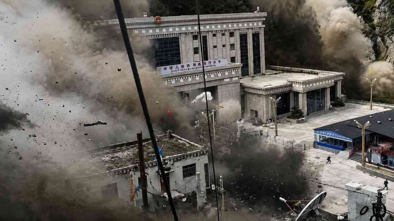
Brivify – The Nepal Flood Disaster has brought renewed attention to the growing hazards facing communities across the Himalayas. The catastrophic flash flood near the Tibet-Nepal border left hundreds dead and thousands missing. Meanwhile, neighboring India has responded by strengthening glacier surveillance in its own vulnerable mountain regions. Authorities are particularly concerned about Uttarakhand, where glaciers, steep valleys, and numerous glacial lakes create a complex natural risk environment. The disaster shows how quickly conditions in high mountain areas can affect communities far downstream. Therefore, glacier monitoring is becoming an important part of disaster preparedness rather than purely scientific observation. Although the exact trigger behind every glacier collapse can differ, changes in ice, water, slopes, and weather can interact in dangerous ways. For Himalayan communities, detecting those changes early could provide valuable time to prepare for potential emergencies.
Read Also: Vauxhall Grandland Review: A Smarter and More Practical Family SUV
India Strengthens Monitoring After the Deadly Flood
India is increasing surveillance of glaciers and glacial lakes following the Nepal Flood Disaster. Authorities in Uttarakhand have instructed relevant agencies to monitor identified high-altitude areas more closely. Field teams are also expected to remain alert for unusual developments that could signal growing instability. This response is understandable because Himalayan hazards do not stop at national borders. Nepal, India, China, and other parts of the region share interconnected mountain systems shaped by similar environmental pressures. As a result, a major event in one area can provide important lessons for another. Monitoring cannot prevent a glacier from changing. However, consistent observation may help experts detect expanding lakes, unstable slopes, or other warning signs. In my view, this shift toward prevention is especially important because emergency response becomes far more difficult once a destructive flood has already entered a narrow mountain valley.
Uttarakhand Has More Than a Thousand Glacial Lakes
Uttarakhand deserves particular attention because of its fragile Himalayan landscape. Government data indicates that the state contains at least 1,266 glacial lakes. While the presence of a glacial lake does not automatically mean danger, some lakes require careful assessment as environmental conditions change. Retreating glaciers can create new lakes or increase the size of existing ones. Meanwhile, natural barriers holding the water may vary greatly in stability. Scientists therefore examine several factors before determining the level of risk. These include lake growth, surrounding terrain, drainage conditions, ice movement, and slope stability. Furthermore, remote mountain locations make regular observation challenging. Satellite imagery can provide useful information, while field inspections offer more detailed local evidence. Combining both approaches may help authorities identify areas that deserve closer attention. For Uttarakhand, the Nepal Flood Disaster has made this type of surveillance even more urgent.
Glacier Collapse Can Unleash Destructive Debris Flows
A glacier-related disaster can involve much more than water. When ice or surrounding slopes become unstable, falling material may combine with rock, soil, and meltwater. The resulting debris flow can travel through steep terrain with destructive force. Communities downstream may have very little time to respond, especially when the initial collapse happens in a remote location. In the Nepal Flood Disaster, a glacier collapse was suspected of triggering a major movement of debris. The scale of the destruction demonstrates why scientists carefully study the connection between glaciers and surrounding mountain landscapes. However, it is also important to avoid oversimplification. A glacier collapse can involve several contributing factors rather than one isolated cause. Temperature, rainfall, geological conditions, ice structure, and slope instability may all influence what happens. Therefore, detailed scientific investigation remains essential after a major event.
The Human Cost Shows Why Early Warning Matters
The reported human toll from the Nepal Flood Disaster has been devastating. By August 29, authorities had confirmed 633 deaths, while nearly 3,000 people were reported missing. Beyond those numbers are families, villages, and communities facing profound uncertainty. Mountain disasters can also isolate survivors by destroying roads, bridges, communication systems, and essential infrastructure. Consequently, rescuers may struggle to reach affected locations quickly. This reality makes early warning systems especially valuable. A warning does not need to predict every detail of a disaster to be useful. Even limited additional time can support evacuations and emergency decisions. However, effective warnings require more than monitoring equipment. Information must travel quickly from scientists and authorities to communities at risk. People also need to understand where to go and what actions to take. Technology becomes most effective when it is connected to clear local preparedness plans.
Climate Change Is Reshaping Himalayan Glaciers
The Nepal Flood Disaster also highlights a much broader concern about the future of Himalayan ice. Scientists have warned that glaciers across the region are retreating as global temperatures rise. This transformation matters because glaciers influence rivers, mountain ecosystems, water supplies, and local landscapes. As ice retreats, new hazards can emerge or existing risks can change. Nevertheless, climate change should not automatically be presented as the sole explanation for every glacier-related disaster. Individual events require careful investigation because local weather, geology, rainfall, and slope conditions can also play major roles. The stronger conclusion is that a warming climate is changing the background conditions in which these hazards occur. Therefore, historical patterns may become less reliable when authorities assess future risks. Continuous observation can help scientists understand which glaciers and lakes are changing most rapidly and where additional precautions may be necessary.
Melting Ice Can Affect the Stability of Mountain Slopes
Glacier retreat can influence much more than the ice itself. In high mountain environments, frozen ground and glaciers can help support surrounding rock and sediment. As those conditions change, some slopes may become less stable. Water can also enter fractures and influence the movement of loose material. Consequently, landslides, rockfalls, and debris flows become important parts of glacier risk assessment. This is one reason monitoring only the visible surface of a glacier may not provide a complete picture. Experts also need to understand the surrounding terrain. Moreover, Himalayan valleys often contain settlements and infrastructure directly below steep slopes. A relatively distant event at high altitude can therefore create serious consequences downstream. The Nepal Flood Disaster reinforces the importance of looking at glaciers as part of a wider mountain system rather than treating them as isolated blocks of ice.
Rapid Development Adds Another Layer of Risk
The Himalayas are home to growing communities that need roads, electricity, housing, tourism facilities, and other infrastructure. Development can improve livelihoods and connect isolated regions. However, construction in fragile mountain terrain requires careful planning. Roads cut into steep slopes, buildings placed near flood channels, and poorly assessed projects can increase exposure when extreme events occur. Therefore, environmental risk should become part of development decisions from the beginning. The challenge is not to stop development altogether. Instead, authorities need to understand where construction can take place more safely and which locations require stronger protection. The Nepal Flood Disaster offers a difficult reminder that natural hazards and human decisions often interact. When changing environmental conditions meet vulnerable infrastructure, the consequences can become more severe. Better planning can reduce that vulnerability even when the natural hazard itself cannot be eliminated.
Read Also: Barcelona Beat Athletic Club 2-0 as Raphinha and Fermin Shine
Technology Can Improve Glacier Surveillance
Modern glacier monitoring combines several types of technology. Satellite imagery allows scientists to observe remote regions that would otherwise require difficult and dangerous expeditions. Researchers can compare images over time to identify changes in glacier boundaries, lake size, and surrounding terrain. Meanwhile, field instruments can provide more detailed information about local conditions. Drones may also support mapping in selected areas where access permits their safe use. However, technology alone cannot guarantee safety. Data must be analyzed correctly and translated into practical decisions. Authorities need clear procedures for determining when a change deserves closer investigation or when communities should receive a warning. In addition, monitoring systems require long-term maintenance and trained specialists. Following the Nepal Flood Disaster, stronger surveillance could help India build a clearer picture of how its Himalayan glaciers and glacial lakes are evolving.
Himalayan Disaster Preparedness Requires Regional Cooperation
The Himalayas stretch across several countries, making regional cooperation increasingly valuable. Rivers, glaciers, weather systems, and geological hazards are not confined by political boundaries. Therefore, sharing scientific observations can help neighboring countries understand changes occurring across the wider mountain system. The Nepal Flood Disaster demonstrates why this cooperation matters. Data collected upstream may provide useful information for communities located farther downstream. Similarly, lessons from one country’s emergency response can improve preparedness elsewhere. Cooperation may include satellite observations, glacier inventories, weather information, research findings, and disaster-management practices. Of course, each country has different institutions and local conditions. Yet the underlying environmental challenges often overlap. Better communication between researchers and disaster agencies could strengthen regional understanding while supporting faster responses when dangerous conditions emerge.
The Nepal Flood Disaster Is a Warning for the Future
The Nepal Flood Disaster is more than a story of destruction in one Himalayan location. It is a warning about the challenges that mountain communities may increasingly face as glaciers, landscapes, and climate conditions continue to change. India’s decision to strengthen monitoring reflects an important lesson: preparedness needs to begin before a disaster becomes visible from downstream. Surveillance, scientific research, early warning systems, responsible development, and community planning all have roles to play. None of these measures can remove every risk. However, together they can improve understanding and reduce vulnerability. The Himalayas have always been a dynamic environment, but today’s rapid environmental changes add new uncertainty. For governments and communities across the region, the priority now is learning how to recognize emerging threats earlier and turn scientific information into practical protection.



Post Comment